Trail Mix: Sapa Strolls, Treks and Scenic Drives
Most visitors to Sapa end up wishing they could spend more time there, and no wonder -- this highland town in northern Vietnam has got it all, from spectacular mountain views to colorful hilltribe markets. Spend a few extra days there if you can, and be sure to check out the strolls, treks and scenic drives listed below.
* * *
Cat Cat Falls
One step at a time
Overview: More country stroll than hike, this short walk provides an excellent introduction to the countryside surrounding Sapa. Most people tackle this trail on their first day in Sapa, when they’re still feeling worn out from the long night-train ride from Hanoi. Trail Route: This hike begins just past the popular Cat Cat Hotel, continues on past the turreted mansion-like HQ for Hoang Lien National Park, and then descends by staircase to Cat Cat Falls. After crossing the river on a plank-floored suspension bridge, the trail then climbs steeply up the other side of the valley before descending to cross the river yet again on another narrow suspension bridge. At this point you can walk back to Sapa or hire one of the waiting motorcycle drivers to take you back on a high-speed ride up twisting mountain roads. Hilltribes: Black Hmong live in an extended village scattered along the river valley. The Scenery: The Cat Cat Falls are picturesque, though nowhere near the size of the famed Silver Waterfall (see below). Fitness Level: Moderate, as the trail features hundreds of concrete steps. Trail Conditions: Cement staircase or sidewalk the whole way. The second suspension bridge has lost some planks, so watch your step. Trail Rules: Cattle and water buffalo always have the right of way. Reality Check: Expect to share the trail with not just backpackers but more well-heeled travelers as well, since tour buses regularly unload their charges at the stairs leading down to Cat Cat Falls. Costs: Though it’s not always collected, foreigners normally pay 10,000 Vietnamese dong (US$0.70) to enter Cat Cat Village, payable at the gatehouse just past the Cat Cat Hotel. The motorcycle ride back from the end of the hike should cost about 10 to 15,000 dong (US$0.70 to 1.00) with a little polite haggling. Guides: This hike is so easy to follow that a guide isn’t necessary. Keep in mind that if you go to Sapa with an organized tour, a guided version of this hike will likely be included in the itinerary. The Kangaroo Café in Hanoi offers inexpensively priced tours to Sapa that consistently get good reviews from travelers .
* * *
Lao Chai and Ta Van
Down by the river
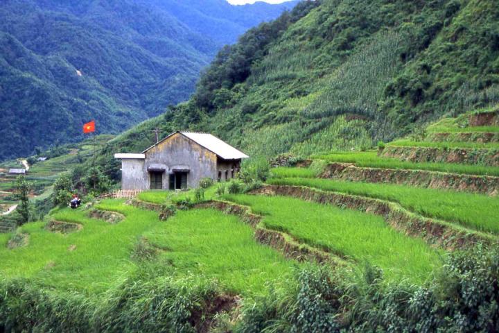
Overview: This hike offers spectacular cloud-shrouded mountain scenery and the chance to walk through traditional hilltribe villages and their surrounding rice paddies. Trail Route: The hike initially follows a mountain road that leads out of Sapa, then descends into a deep valley, crosses the Ta Van River, and winds through rice paddies and the spread-out homes of Lao Chai and Ta Van villages. Eventually the trail crosses back over the river and rejoins the road, where most hikers then hire a jeep or motorcycle for the return ride to Sapa. Hilltribes: Black Hmong and Day communities line the hiking route. The Scenery: From the road you’ll get an absolutely stunning view of the mountains across the river valley as well as the villages nestled down in the valley itself. In the summer, expect to see luminous green rice paddies. Duration: 3 to 4 hours at a reasonable pace, assuming you take a jeep back to Sapa; add another two hours minimum if you don’t. Fitness Level: Moderate. Trail Conditions: Construction crews are currently improving the road out of Sapa, so expect to encounter torn-up portions of pavement with axle-deep mud and piles of blasted rock. The trail down into the valley can be steep and slick in spots, so be sure to buy a bamboo walking stick from one of the local Hmong kids for 2,000 dong (US$0.15). Don’t wear your best shoes and pants, as the trail’s rust-orange mud can permanently stain your clothes. Trail Rules: Behave as if you’re walking through somebody’s front yard, because often you will be. And remember that while this hike is a photographer’s dream, you should ask first before taking pictures of anyone you meet. Reality Check: In just a few years this hike has become highly popular, so expect to share the trail with your fellow travelers. Costs: Try to buy something from the locals, even if it’s just a lukewarm can of Coke. They’re desperately poor and need the cash, which is one reason why foreigners must pay 10,000 dong (US$0.70) to enter the Lao Chai area. You pay the fee at the gatehouse on the road out of Sapa. Guides: Though the trail has become so well established that you could probably hike it on your own without great difficulty, you’ll get more out of the hike if you hire one of the local Hmong teenagers as a guide. These self-assured young women can explain Hmong culture, interpret what the locals say, and tell you their own fascinating life stories -- and they can do all this in startlingly good English. Keep in mind that if you go to Sapa with an organized tour, a guided version of this hike will likely be included in the itinerary. The Kangaroo Café in Hanoi offers inexpensively priced tours to Sapa that consistently get high marks from travelers.
* * *
Silver Waterfall (Thac Bac) and Tram Ton Pass
Don’t pass on this one
Overview: Jeep or motorcycle ride to the 300-foot (100 m) Silver Waterfall and 6,200-foot (1,900 m) Tram Ton Pass. Trail Route: Drive five miles (8 km) out of Sapa to the Silver Waterfall, then continue another four miles (7 km) to Tram Ton Pass. Retrace the same route back to Sapa. Hilltribes: Black Hmong live in the area, but no villages are in the immediate vicinity of the pass or falls. The Scenery: The waterfalls are impressive and the pass offers a stunning view of the road to China’s Yunnan Province. Duration: 2 to 3 hours, but confirm how long you have hired the jeep for before setting off, as the driver may have a schedule to keep. Fitness Level: Moderate, because while the waterfalls can be seen from the road, you will probably want to scale the staircase that climbs beside it for a better -- and wetter -- view. This cleverly engineered route features a bridge that crosses in front of the cascades about half way up the falls, allowing hikers to ascend down the opposite side. The view from Tram Ton Pass can be seen from the road and requires no hiking whatsoever. Trail Conditions: The road can be bumpy, especially in the no-frills ex-army jeeps used by most drivers, so expect a slow ride. The trail at the waterfall consists of concrete stairs and is in excellent condition. Trail Rules: Be very careful if you deviate from the staircase trail beside the waterfall. Reality Check: The scenery is beautiful, but all of it lies in the endangered Hoang Lien National Park. Keep in mind that the waterfall can be a washout during the drier first half of the year and that clouds often sweep over the pass and reduce visibility to near zero. Costs: Foreigners are theoretically required to pay 3,000 dong (US$0.20) to climb up alongside the waterfall, but nobody seems to be bothering with collecting the fee. Jeeps to the falls and pass can be hired for US$12, which is a real bargain considering you can split the cost among five passengers. If you want to go it alone, Minsk motorcycles can be rented for about US$8 a day. Guides: If you hire a jeep, your driver will know the route, so no guide is needed; if you drive your own motorcycle, you’ll want to pick up a map at the Sustainable Tourism Information and Service Centre on Cau May Street in Sapa, which sells maps of Sapa and the surrounding areas for 15,000 dong (US$1.00).
* * *
Ta Phin
Mountain valley outside of Sapa
Overview: Several hilltribe villages lie in Ta Phin, a misty valley nine miles (15 km) out of Sapa. Trail Route: Jeep or motorcycle ride down the main road to Lao Cai, with a left turn down a side road to Ta Phin. If you’re driving your own motorcycle, be warned that this turnoff is not marked. You’ll know you are on the road to Ta Phin when you pass the haunted-looking ruins of a burnt-out French seminary. Within Ta Phin valley there are any number of possible trekking routes, though most people follow the main trail leading through a Hmong village and up to the Ta Phin caves. Hilltribes: Black Hmong and Red Dzao live in neighboring villages. The Scenery: Luminous green rice paddy and traditional villages set in a highland valley ringed by mountain peaks. Duration: Variable, as you could easily spend a whole day here. Most people take about 2 to 4 hours total. Fitness Level: Easy to moderate in spots, especially in the caves. Trail Conditions: Generally good, as the main “roads” are mostly concrete sidewalks sized for motorbikes rather than cars. Trail Rules: Always ask before taking photos, as the Red Dzao are particularly camera shy. Reality Check: This mountain valley has an idyllic feel to it, but keep in mind that tending those rice paddies is back-breaking work barely sufficient to feed local families. Also, while Ta Phin is a great way to get outside Sapa, it’s hardly undiscovered. Expect to spot some of the same foreign faces you’ve been seeing in the cafes and restaurants of Sapa. Costs: Foreigners pay 10,000 dong (US$0.70) to enter Ta Phin valley, payable at the gatehouse near the ruins of the seminary. Xe om motorcycle taxis can take you to Ta Phin for US$2 to 3 one-way, while jeeps can be hired for US$12 round trip. Alternatively, you can rent your own motorcycle for about US$8 a day. Guides: You’ll get more out of your visit to Ta Phin with a guide, who will speak English and be able to offer you insights into local hilltribe culture. In some cases, they will invite you into their homes. Often no fee is charged, though in these cases, be sure to buy something from your guide at the end of your hike, and don’t bargain too hard when you do. The dong you spend will help feed, clothe and school local families.
* * *
Coc Ly Market
Want to buy a water buffalo?
Overview: The market at Coc Ly literally lies at the end of a road that winds along the scenic Green River. Because of its remote location, both the merchants and the customers are almost all from various hilltribe groups. In fact, ethnic Vietnamese look almost as out of place here as foreigners do. Aside from the expected water buffaloes, other goods for sale include a wide array of food, clothing and practical items like tools and corrugated metal roofing. The market is in full swing only once a week, usually on a Tuesday. Trail Route: About 100 miles (160 km) from Lao Cai, or a three-hour road journey. Hilltribes: Black Hmong, Flower Hmong and Tay all frequent this market. The Scenery: The market sits above the Green River, which you can cross on a narrow suspension bridge straight out of an Indiana Jones film. You can also hire a boat for a run down the river through limestone gorges and isolated villages. Duration: If you opt for the boat trip, this is really an all-day affair. Expect to spend a good chunk of that time driving to and from Coc Ly. Fitness Level: Easy. Trail Conditions: The market can be jam-packed on busy days, so expect a crowd. There’s not much to keep you from falling off the middle of the suspension bridge, so those who are afraid of heights will want to give it a miss. Trail Rules: Though it’s rapidly being “discovered,” Coc Ly is still largely off the tourist trail. Try to leave a small footprint. Reality Check: Though they are cheerful and colorfully dressed, the locals lead extremely difficult lives marred by poverty. Guides: Ms. Loan, owner of the popular Cat Cat Hotel, can organize a guided minibus trip to Coc Ly. For a bit more cash, she can send you off in your own jeep. If you don’t mind getting lost or breaking down in the middle of nowhere, you can skip the tour and rent your own motorcycle for about US$8, plus gas and the inevitable fees for roadside repairs.
* * * * *
 ThingsAsian